Click HERE for the SiteMenu
West End Village: 1
Around and about the area

blankbutt.gif (105 bytes)

corner-topleft.gif (1024 bytes)   corner-topright.gif (1029 bytes) blankbutt.gif (105 bytes)


West End Villagetiniball.gif (953 bytes)  The village started life as a sparse collection of farmsteads on what became known as the "West End Of Chobham" ("End" simply means outlying place), the picturesque village where evidence of a settlement stretches back to the Bronze Age. Chobhams' borough originally covered a large area both to the east and west, once simply part of the huge tract of open country called the Forest Of Windsor which ran roughly between Guildford, Henley, Staines and Maidenhead.

tiniball.gif (953 bytes)  
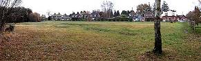
Long-held rights ensured locals used West End Common extensively to build their homes and graze their livestock. Much stone, sand and gravel was removed, and turfs and small trees were regularly "harvested". This continuous activity over many centuries was important to the economy of the poorer peoples of West End and was a major factor in the way the Common developed into its individual heathland character seen today. The Common was crossed in all directions by ancient paths and roads, of which Brentmoor Road gave an easy route to Frimley and Pirbright. Spaces in the area that now centres just south of the famous Gordon's School (on the A322/A319 junction) gradually started filling in between the farmsteads as more of the poorer Chobham parishioners looked to improve their lot. 

Early Years

Click for the larger 1873 map

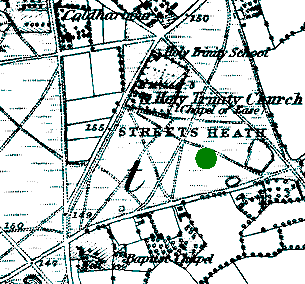
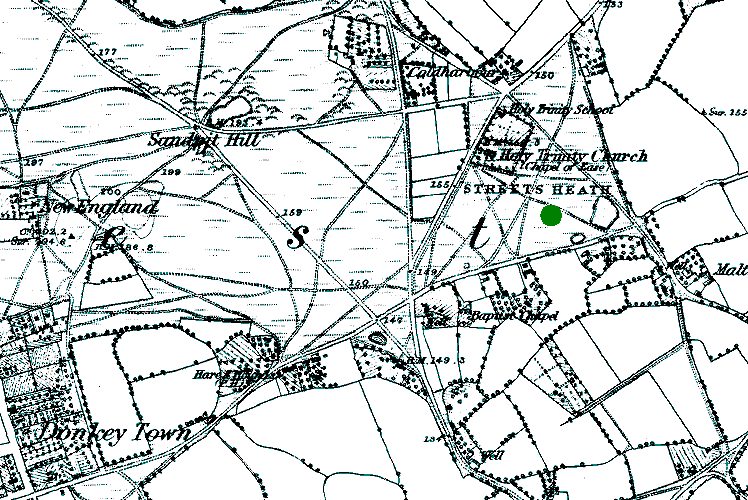
WECC's current wicket is indicated by the green dot. Click above for an enlarged map view that includes the whole locality. (203k)

tiniball.gif (953 bytes)  Near the bottom of the map (c.1873) you can see the Streets Heath road off which is the Baptist Chapel which dates from around the start of the 19th century. It closed around the time of 
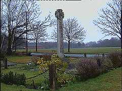
the Great War. Near the top is seen Holy Trinity Church, consecrated in 1842 and extended many times over the years. Originally, this "Chapel Of Ease" had a gallery and its clerical needs were administered by successive Chobham vicars who were assisted by curates. The last wooden grave board was preserved and now resides in the Surrey Heath Museum at Camberley. A Vicarage was to be built on the land next to Holy Trinity, at the junction of Benner Lane and what is now the A319 Chobham road. This never happened and Holy Trinity School was erected instead with the help of The National Society around 1845. Before then, children needed stout footwear to walk miles into chobham, often in the dark on the notoriously poor local tracks.

tiniball.gif (953 bytes)  Around this time cricket gets mentioned in a journal of the day and this could mean that the game had been played in the village for some while, even then. A railway link between Staines, Bagshot and Woking was proposed, along with a station at West End, however it never materialised. Presumably this was the same project that the ticket-office at Chobham (now the Castle Grove public house) was built for. 1860's records show ten occupations, including farmer and labourers, shoemaker, blacksmith, hawker, carpenter, sawyer and shopkeeper. There were also two public houses since the early 19th century, both of which in use today.round this time cricket gets mentioned in a journal of the day and this could mean that the game had been played in the village for some while, even then. A railway link between Staines, Bagshot and Woking was proposed, along with a station at West End, however it never materialised. This was part of the same project that the ticket-office at Chobham (now the Castle Grove public house) was built for. 1860's records show ten occupations in West End, including farmer and labourers, shoemaker, blacksmith, hawker, carpenter, sawyer and shopkeeper. There were also two public houses since the early 19th century, both of which in use today.

blankbutt.gif (105 bytes)
blankbutt.gif (106 bytes)
Map produced from the Ordnance Survey Get-a-map service. Image reproduced with kind permission of Ordnance Survey and Multi Media Mapping.


The "Old Cricket Green" today. The "Hare & Hounds is seen to the right of the tree

tiniball.gif (953 bytes)  The increasing use of the Common by the Army through the 1800's culminated in their seizing it in 1879 and West End Commoners' rights of centuries past ended overnight. Access to the many roads and paths were curtailed too: Brentmoor Road with its shops and pub was the main route to Frimley. When the ranges on the common were in action, the occupants of Colony House were prevented from going outside. Thus it was no surprise when it was first abandoned, then later demolished. Subsequent to the events of 1879 severe poverty hit the area and illness became prevalent, especially Scarlet Fever which returned many times to the village. As there were no running taps water had to be either pumped or drawn by buckets from wells. Poor parents were unwilling (or in a lot of cases unable) to pay the required school fees.

tiniball.gif (953 bytes)  The Army gave up a small piece of land for the construction of a two-room village Institute, for which money was raised by a committee chaired by the then Vicar, the Rev. O. F. Glanville and it opened on 1st November 1886. A year later came a more significant event when land was acquired for the Gordon Boys Home, built in memory of General Gordon of Khartoum. Backed by many members of the Establishment including the Prince of Wales and the Duke of Edinburgh, the striking building on the hilltop housed and trained destitute or homeless boys for trade or military careers and was quite self sufficient, having its own water, hospital and chapel.

tiniball.gif (953 bytes)  Despite all the drawbacks of the period the West End growth rate gradually increased and records from near the end of the nineteenth century show more shopkeepers, market gardeners, plus "Gravel Getters", a printer and a gamekeeper amongst a wider range of occupations. In 1895 the parish underwent a re-organisation where the Rev. Christopher Haggard, West Ends first vicar proper (appointed the same year) was placed as chairman of the school management committee. Under his leadership it ran smoothly but changed for the worse on his retirement three years later aged 69. His replacement was the Rev. Mills Robbins, a domineering man who was not easy to get on with. Hence the locals nicknamed him "The fighting Parson" which in itself is a double meaning as he held boxing lessons for boys in the Streets Heath Baptist Chapel before it fell into disuse. For the record, Robbins' name appears on West End cricket club's documentation of the time as a "subscriber".

blankbutt.gif (105 bytes)
blankbutt.gif (106 bytes)


Into the 20th Century

tiniball.gif (953 bytes)  The regularly overcrowded school building was heavily criticised in a report of 1906 for its poor repair and dirty conditions - even basic things we take for granted today like soap and towel were missing. By the following year the four classes totaled 203 children. Mr. Bradbrook - who took over as Headmaster and stayed for 31 years - began a drive to improve both conditions and standards and a new initiative of gardening classes was introduced. An associated pig-raising scheme was so successful that a Kent Education Committee official visited in order to obtain details. The Rev. Mills Robbins had other ideas and the gardens and sties were removed in 1921, the shed and tools being taken to another school in Godalming. After Robbin's death in 1924 his replacement (a Rev. W. H. Smythe) re-introduced the gardens. A succession of Headmasters then overlooked gradual improvements to the school over the following decades.

West End Memorial
The "Rec" is in the back - Holy Trinity Church is just beyond view on the left

tiniball.gif (953 bytes)  Electricity didn't arrive until the end of the 1920's and the following decade saw the locals again experiencing much unemployment and poverty as did most of Britain through the Troubled Thirties. World War Two literally made an impact in September 1940 when a Heinkel 111 Bomber crashed on Streets Heath (then still heathland), narrowly missing both the church and school. Its engine ended up in the grounds of the Gordon Boy's school. The Army moved swiftly in and cleared away all traces of the aircraft. Four years later two Flying Bombs exploded near Halebourne, damaging windows as far away as the Wheatsheaf Pub (now the "Inn At West End") on the Guildford Road. Main Drains eventually arrived in West End in 1960, a boon to the village population which was rising faster than ever since the end of the war. An indication of increasing traffic through West End is borne out by a road crossing patrol appearing for the first time at the dangerous Brentmoor Road junction with the Guildford Road.

New Website devoted to villages in our area, including West End!

Origins of the village     Recent times & around the area

blankbutt.gif (105 bytes)
corner-bottom-left.gif (1030 bytes) corner-bottom-right.gif (1029 bytes) blankbutt.gif (105 bytes)

blankbutt.gif (105 bytes)

westendcc@yahoo.com

Pages maintained by Adrian Barrett